“Bin stores and 1.8 metre high railings and sliding gates to enclose the site” (Grant ST/042917FUL) does not exactly cover the fence we see today and nor the removal of the foot path. This alone, suggests a certain amount of collusion between the planning office and planning control (building inspection and enforcement).
As one can see, the foot path and railings continue to hug the high water line round the partially filled dock and continued past numbers 21 to 14, Long Row until we get we get to point A with the 2.3m gate which is now completely under the control of Mark Turnbull of 30 Quayside Court.
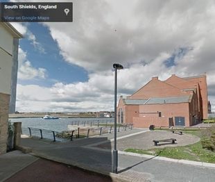
The mostly filled Market Dock was landscaped and some pleasant seating provided by the Council and notice some some lighting had also been provided by them as well. The same street light is clearly shown on the extreme right the view taken from Google Street Scene.
Not only does “Bin stores and 1.8 metre high railings and sliding gates to enclose the site” (Grant ST/042917FUL) fail to cover the fence blocking off the north end of the old Garlands Centre it fails to cover the fence blocking the way from the South via Long Row.
It appears that the planners have taken the footpath and the gardens laid out by the Council more than 10 years before the plans for the boat lift were made, away from the public and given them to the owners of the ground floor properties of the two sites now known as South Quays which course includes the nearest flat to the boat lift and that happens to be Mr Turnbull’s.
The application for these were submitted in March 2018 by the agent Mario Minchella and approval for them was granted by the Head of Development Services in April 2018. It does not appear to have gone before any Committee and it was put there as a result of the grant, ST/0201/18/FUL -see especially points 8 and 9.
The detail taken from the site plan for it suggest that the gate was placed in front of No. 14 long row at the same time to stop people getting access to the gardens given to owner of Apartment 30, by walking round in front row of houses facing the big dock where the gate appeared in 2018 or 2019. It appears to be in place by the time the planning application, see existing security fence with gate, for the pontoon was made in June 2020.
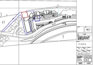
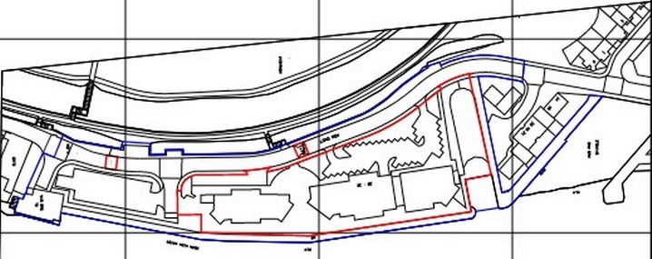
None of this is shown on on the site plan for ST/042917FUL which is given below, rotated, to match the plan of the English Coastal Path shown in the top, and there is definitely no record of any retrospective planning consent for the removal of the right of way, and retracing our steps, none for the gate, the southern fence and removal of the railings round the dock and none for the northern fence and the removal of the flags that paved the footpath. Nor any for the removal of the paving of the overspill car park!
Mick Dawson, 09 -Oct-21
The last two illustrations from my post of October ’21 are details from drawings produced by the Architects, Mario Minchella and in points 8 and 9 it appears that the Head of Development Services, Mr George Mansbridge gave a section of the England Coastal Path to Mr Mark Turnbull of 30 South Quays, Long Row and others with flats in the former Call Centre and he did it with the help of the architects who redrew the boundary of South Quays, the red line, to include the riverside stretch of the now, King Charles III England Coast Path as part of their properties.